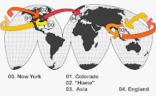
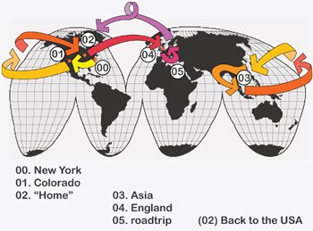
 Again, if you're waiting for UK news, you'll have to bear with a few more summary-type Asia posts (we're fine, though, mom...). Personally, I think the best summary is a diagram (thank you, Columbia GSAPP)! The map above shows our route for the last 5 or so months and was made today. You can check out my hand-drawn maps by clicking on the link below. These lovely things were created en-route and take full advantage of the three different colored pens we brought with us. All the maps should zoom in a bit if you click on the images themselves.
See the rest of the maps.
 Map 2: 5/15-6/14 Hue, Vietnam to Thai/Malay border
 Map 2b: 5/19 the super treck in Sapa, Vietnam
 Map 2c: 6/5 biking the ruins in Sukhothai, Thailand
  Map 3: 6/14-6/30 Malaysia and Singapore
  Map 4: 7/5-8/10 Yangon, Myanmar to Kathmandu, Nepal
 Map 4b: 7/7-7/8 Biking the ruins in Bagan, Myanmar
 Map 5: 8/10-9/10 India including Andaman Islands
Sunday, October 07, 2007
The trip in visual form
Map 1: 5/4-5/16 Cambodia to Hue, Vietnam
![]()
Subscribe to:
Post Comments (Atom)
1 comment:
Megs, You amaze me!
Post a Comment